Sunday, October 31, 2010

So Much Older Then, Younger Than That Now

It's been hard to do any serious planning for this trip without knowing where we're going to be, especially because the new destination is so completely different from the old one. We are changing from swamp to river, we're going northwest instead of southeast, and instead of moderate November temperatures it's pretty much guaranteed to be freezing cold. But Ozark rivers are like so many rivers we've done before (the Stones, Duck, Piney, Green, Buffalo, Sequatchie, Yellow Creek are all similar) that we should be able to do it with our eyes closed. For a Club like ours, this is not rocket surgery. Still, we should cover a few things.

If you bought a plane ticket to Jacksonville, save it. We will try again in the spring. March and early April are the best times to go just FYI.

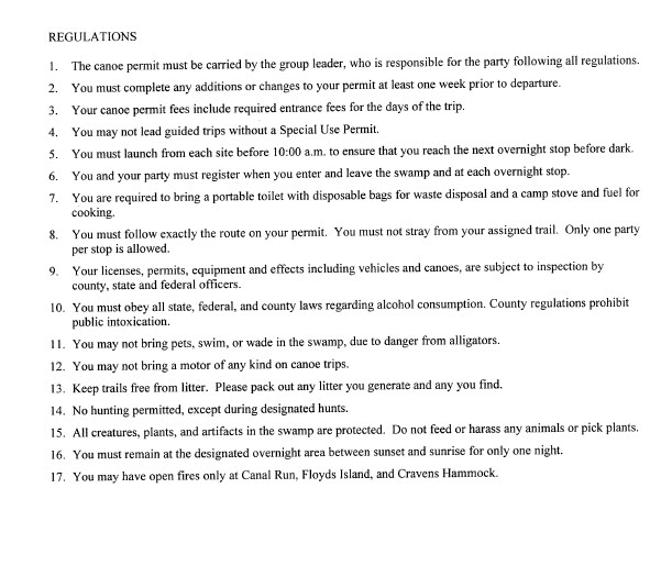
Departure: We had planned to leave for the Okefenokee after work on Thursday the 11th because the park and the alligators demand that you put in before 10:00 am. Lest darkness should fall before you reach your platform. Now, according to MapQuest, it is 5 hours and 27 minutes from Brown's Diner to our new put-in in Missouri and we have no real deadlines. So, since we were all planning to miss work Friday anyway, it seems the thing to do is leave Friday morning and still spend two nights on the river. We'll decide on an exact time later but count on leaving early Friday.

Camping options: The land along the Eleven Point is all public. In addition to Wild & Scenic River status, it is within the boundaries of the Irish Wilderness Area which itself is in the Mark Twain National Forest. Not only does that make the gravel bars fully legal (not that we have ever really cared), but the Missouri D.N.R. has built what they call "Float Camps" at various points along the river. Like this one called "Barn Hollow":


The existence of the Float Camps creates a dilemma for us. Our first choice is and always will be to camp on gravel bars, preferably next to a riffle or rapids. But having not been on this river in, oh, about 25 years, we don't really know where they are. We know exactly where the Float Camps are from the maps and they would give us complete certainty in planning, but they are a little less desirable because they can be grassy places with muddy banks. And there is also the problem of working out the right mileage between them. We know we want to put in at Greer Spring to get the best water level and we do know there is a Float Camp ten miles downstream which would work well because Greer Spring has a developed campsite at the put-in.

So this is our choice: (a) take the cautious approach - with the first night at a drive-in campground and the second night at a DNR Float Camp or (b) roll the dice and spend both nights somewhere downstream on two gravel bars we hope we will find. It is a riddle, wrapped in a mystery, inside a conundrum. The last time we did a trip without knowing where we were going to stop was on the Green River and we were sweating bullets until we found (what turned out to be) the last gravel bar before the take out.

But it was a good one.


Young, one moves in upon the country and thinks himself a tile in its tessellated ecology, and believes that he always would have been such a tile, and hoots with the owl, and scorns even tents.

Older, one knows himself an excrescence upon the landscape and no kinsman to any wild thing; one hears the bass drumbeat and the gabble of the rapids below and the roar of the rain and feels abrupt depression and wonders why he barged out alone into the wetness and the winter. And thinks that perhaps, in the old time, he would have been one of the cautious who stayed in the jammed East.

I lay awake for a long time with a kind of three-o'clock-in-the-morning apprehension on me. The pup shivered against my side. The river boomed and burbled against its rocks. The night was black but starry. The wind kept on in the darkness, unnaturally; later I woke once or twice as it popped the tent flaps. Big wind depresses when it continues without the normal wanings of evening and night and dawn, whether it's called sirocco or khamsin or whatever. I lay feeling soft muscles ache and wondered if they would tauten to the work or whether I'd finally arrived at that point where the body won't snap back into tone with a few days' misuse, and wondered too what weather the wind might portend, and what idiocy had brought me out there to lie on the graveled ground, in November. . . .


Goodbye to a River, p. 67

Thursday, October 28, 2010

Member Recognitions

The RRCC would like to extend special thanks to Dr. Sands who helped select the the Eleven Point as our alternate river after hours of subcommittee meetings in the parking lot of Municipal Auditorium last week.


CONSULTING WITH THE AUTHORITIES


And a double dose of Vagisil goes to the Beverage Manager, who intends to be "too busy at work and home" in mid-November to go on the trip. Note to Tim: if you thought you were avoiding the swamp trip you're in for a big surprise. We'll be back at the Waffle House about January.


~


~

Wednesday, October 27, 2010

Here's a good, slightly funkadelic video shot on the Eleven Point by a couple of blackberry eating hippies. Probably a little farther upstream than we will float but it shows some of the springs that will be helping us along downstream...


Another good one:

Monday, October 25, 2010

"Show Me" Another River

It did rain a little, but the Okefenokee canoe trails are all still closed and would have to come up almost two feet for us to make the trip. That is looking pretty unlikely, so with less than three weeks to go it's time to seriously consider another option.

For our selection criteria, we decided to go with knee-jerk reaction and overcompensation - prized attributes in the RRCC. We figured that if we're getting shut out because of low water levels, then we'll just go wherever the biggest, baddest high-volume natural springs are within a day's drive of here and we'll be drought-proof.

The Ozarks of southern Missouri are famous for that - all of the canoeable rivers there have headwaters called "Mammoth Springs" and "Big Springs" and other names that suggest massive discharges of water that will sweep us and our cast iron happily downstream. One of the best rivers in the Ozarks, and the one with the most springs of all, is the Eleven Point. Therefore, we decree that the Eleven Point River is the Official Alternate River of the RRCC for Fall 2010.


ELEVEN POINT RIVER

Nice, isn't it?


The Eleven Point is in southern Missouri just west of the Bootheel, right on the Arkansas border.

It gets most of its flow from fabulous Greer Springs, which is like having a whole nother river come gushing out of a cave in the middle of the trip. 222 million gallons per day.


There are dozens, maybe hundreds, of smaller springs all up and down the Eleven Point. Not to mention perfect gravel bars, limestone bluffs and (because of the springs) crystal clear and ice cold beautiful blue-green water.


In 1968, Congress passed the "National Wild and Scenic Rivers Act":

It is hereby declared to be the policy of the United States that certain selected rivers of the Nation which, with their immediate environments, possess outstandingly remarkable scenic, recreational, geologic, fish and wildlife, historic, cultural or other similar values, shall be preserved in free-flowing condition, and that they and their immediate environments shall be protected for the benefit and enjoyment of present and future generations.

The first eight rivers to receive the Wild and Scenic designation under the law were the Middle Fork of the Clearwater and the Middle Fork of the Salmon in Idaho, the Feather in California, the Rio Grande in New Mexico, the Rogue in Oregon, the St. Croix in Minnesota and Wisconsin, the Wolf in Wisconsin, and the Eleven Point River in Missouri.

Although now there are 156 rivers on the list, there is only one in Tennessee and the RRCC will never canoe it.


OBED RIVER, TENNESSEE.
No fun for dogs or drunks.


And even though Missouri has legendary canoeing streams in the Ozarks like the Current River and the Jack's Fork, to this day it still only has one on the Wild and Scenic River list. Unless the swamp rises dramatically, we're going to be on it in about three weeks.

Monday, October 18, 2010

The answer to the question you're all asking is we don't know. RebelRivers.com is paralyzed with indecision until we know more about the water levels in the swamp. But if we don't go to the Okefenokee the trip will still be that same weekend, so don't pack away your swinging beverage holders for the winter.

Wednesday, October 06, 2010

Our Permit Has Arrived


Regulation No. 7 sounds like a job for the Beverage Manager.


And an item of interest from the court docket today: