The rain is not doing us any good, and in the event we actually got enough water we'd have less gravel bar which could be a problem since we're up to 13 people, 3 dogs, 2 pigs, 1 mullet and a washtub bass. Here's a map of the Duck:

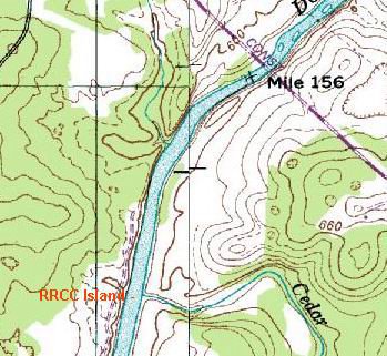
Once again, we will be headed for an island right at the mouth of a creek. It's in the middle of the river just across from Cedar Creek on this map, even though it doesn't show an island....which is ironic because on the Red River the map showed an island that wasn't really an island at all. Maybe the Bell Witch had something to do with that. But this one is a real, honest to goodness island "entire of itself". And that should be reason enough to change plans, as those of you who have done your reading already know:

The island does show up on the aerial photo. We'll be on the upstream tip, looking straight up Cedar Creek at a small waterfall that we can use to reenact the Hamm's Beer Sign-O-Rama with Jim's red Old Town canoe....
The campsite is about nine river miles from the Carpenter Bridge put-in and is less than a mile downstream from Sowell Mill Road bridge. Our take-out will be at Howard Bridge on what was always called Negro Creek Road. The creek itself apparently has kept the name, but the road is now called "TVA Road".

.
.
.
.
.
.
.
.
.
.
.
.
The Book has something to say about this phenomenon also:
CHAPTER NINE
Likely the bluff had a good name once before some dullard called it Inspiration Point. The nation's map is measled with names like that, pocks from the old nineteenth-century plague that made people build gazebos and well-tops of rough masonry with oaken buckets on ropes but no well beneath (unless it was a "wishing well"), and sing "Annie Laurie," and read Scott for his worst qualities, and long to own paintings by Bouguereau and, disregarding the guts and soul in the old nomenclature of American places, rename them Inspiration Point and Lovers' Retreat and Maiden's Leap. It is worst of all in the South, because the South yearned hardest to believe Scott, but the whole hinterland had the disease; in the Midwest it got flavored with Hiawatha
Now that the land looks a little older and we don't have to stare directly at the tobacco juice on the haired chins of those who made its past, the grandchildren of the Gothicists are likely to be enchanted to find that the streamlet below their house used to be called Dead Nigger Draw, but they have a hard fight with the real-estate men, staunchly Gothic all, if they try to cancel out its present title of Bonnie Brae. . . And the effort, somehow, seems little more praise worthy or genuine than their grandparents' was.
No comments:
Post a Comment