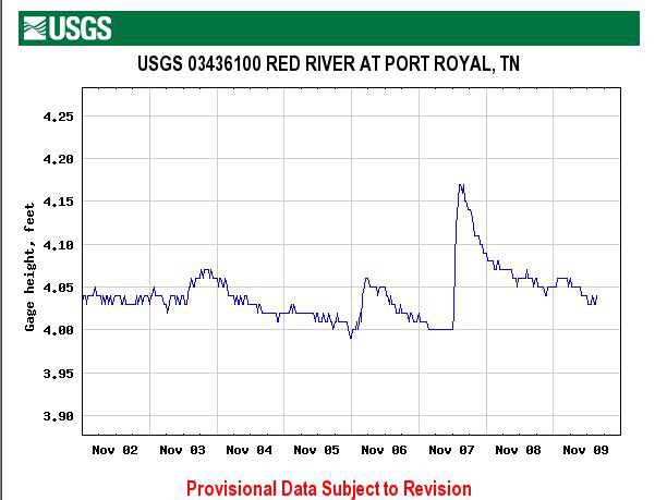
There's a link on the right that shows the USGS gauges for Tennessee. Scroll down to Montgomery County and find the Port Royal gauge on the Red River. Ignore the first graph ("Discharge/cubic feet per second") and go to the second that shows gauge height in feet.
Here's what it looks like today:
Here is the "What It Means To Us" scale for this section of the Red:
3.0 Anything with a 3 in front of it is very low. Upper 3's is passable but lots of dragging. Lower 3's is probably just not worth it and we'll go to a different river.
4.0 Low 4's is ok. Occasional dragging with an empty boat, more if heavy. Upper 4's and our section can be floated pretty much the whole way without dragging if you know how to find the deeper channels.
5.0 Ideal. When the Red is in the 5's it makes a perfect, lazy float trip.
6.0 Ditto. Except add adjectives like "fast" and "fun".
7.0 Getting pushy.
8.0+ Time to go to Knoxville for the big game.
Also, before praying for rain and a 6.5 next weekend, keep in mind that some (maybe most) of the best gravel bars may be underwater at that level. The RRCC archives say that the river was at 4.1 feet when the pictures of the campsite were taken (see below). We might float right over the top of that one if the river is two feet higher.
No comments:
Post a Comment