*************************************************
REMINDER: We are meeting at the put-in at 10:00 am Friday. Those riding with me and the trailer, meet at my house at 7:30 am. Direction to put-in are at the bottom of this post.
*************************************************
UPDATED ROSTER and CANOE ASSIGNMENTS
Looks like Tim can't make the Friday morning departure which means he'll either be coming down the river solo Friday afternoon or coming down the CR 1788 Saturday morning. Myers is still a maybe. So things are in flux but here you go:
Trailer (9)
Skip (Old Town)
Rob (Dagger)
Cronin (Own boat)
Kirk (Grumman)
Josh (Own boat)
Bob (Yellow Folbot)
Phil (Own boat - YES!)
Dave C. (Own boat)
Vernon (Bell or Tim's Wenonah)
Rob's Suburban (1)
Pete F. (Own boat)
Mullowney's Truck (2)
Mullowney (Own boat)
Mullowney's Friend (Delta Dawn)
Tim (Wenonah if come Friday, ride tandem with someone if come Saturday)
Myers (TBD)
UPDATED MENU
Pete F'in Feldman has the following modifications/amendments to the menu:
Friday dinner
Tuna crudo and Celestial stir fry
Saturday lunch
Portuguese shrimp rolls
Please make note of it.
FLOAT PLAN
This trip will be mostly unscouted as far as campsites go. With the exception of the first three miles, it's all new river to me. So we will choose our Friday and Saturday night spots based on mileage, available daylight and aerial photos.
As previously mentioned, we'll probably divide the 16 total miles up into something like 5-8-3 assuming a noon or shortly thereafter launch Friday. The Boy Scout Canoe Base is 3 miles from our put-in so we'll want to clear that Friday. The County Road 1788 Bridge is our max distance Friday because we need to be upstream of that for potential Saturday morning arrivals at that bridge, but it is 7 miles down and we prefer not to go that far anyway. That means the possible range is between River Mile 56 (3 miles) and River Mile 52 (7 miles).
It looks like there are lots of really good options in that stretch. Turn off your porn blocker if you want to click on any of these gravel bar photos.
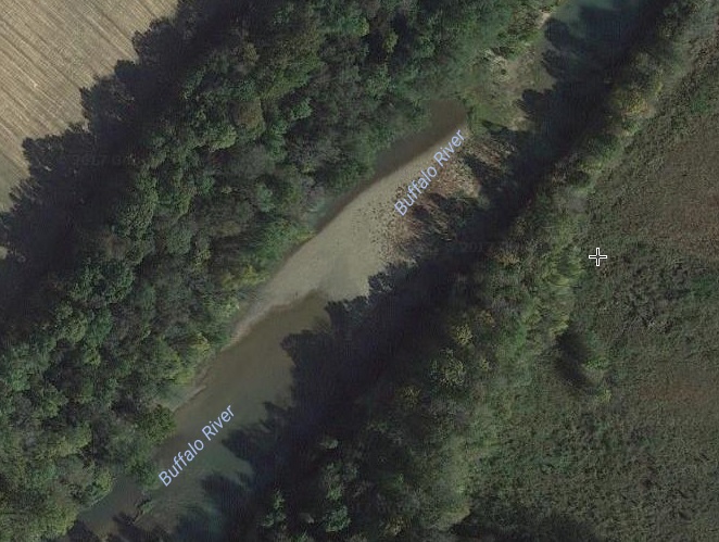
RM 55

RM 54.5

RM 54

RM 53 (Upstream)

RM 53 (Downstream)
It's amazing how much better the aerial photos are than when we first started doing these trips. Now you can even scout for Nine Man Logs by satellite:


PUT-IN LOCATION (10:00 am Friday)
The exact location of the put-in will be a gravel bar on the north (downstream) side of the Highway 13 bridge between Linden, TN and Flatwoods, TN.
If you are coming from the north (I-40) it will be the first bridge that crosses the river on Hwy. 13 after you pass Linden (so about 10 miles south of Linden).
If you are coming from the south or east it is just a mile or less up Hwy. 13 from Flatwoods.
It looks like the closest physical address is "10179 Tennessee 13" if you want to try that in GPS. Also nearby is the Grimes Canoe Base (on the north/Linden side) and Flatwoods Canoe Base (to the south).


It's a 2 hour drive from Brown's Diner. See you tomorrow.
If you are coming from the north (I-40) it will be the first bridge that crosses the river on Hwy. 13 after you pass Linden (so about 10 miles south of Linden).
If you are coming from the south or east it is just a mile or less up Hwy. 13 from Flatwoods.
It looks like the closest physical address is "10179 Tennessee 13" if you want to try that in GPS. Also nearby is the Grimes Canoe Base (on the north/Linden side) and Flatwoods Canoe Base (to the south).

There is a surprisingly nice and apparently new exit ramp off of Hwy 13 on the south/east side of the bridge that quickly turns into a gravel road. The pull down to the gravel bar will be on that road, on your left, about 1/2 mile from that exit ramp.

It's a 2 hour drive from Brown's Diner. See you tomorrow.
No comments:
Post a Comment